Cold front may bring summer snow to Tahoe Region

TRUCKEE, Calif. — Summer temperatures across the Tahoe Basin are expected to come to an abrupt end this weekend as an unusually strong cold front moves through the region, bringing significantly cooler temperatures, strong winds and even the possibility of light snow.
According to the National Weather Service in Reno, temperatures will remain seasonably warm through Thursday, with highs in the upper 70s to low 80s across Sierra valleys and low-to-mid 90s across western Nevada. However, 20 to 25 mile wind gusts are expected Wednesday afternoon, increasing to 20 to 30 mph by Thursday.
Forecasters say a major weather pattern shift will arrive Friday and Saturday as a strong cold front sweeps across much of the Great Basin.
“This front will take us from being about 10 degrees above average to around 20 degrees below average by Sunday,” the National Weather Service said in its forecast discussion.
The transition will bring widespread gusty winds, with a 20% to 50% chance of wind gusts exceeding 40 mph across the eastern Sierra and western Nevada on Friday and Saturday. Sustained winds of 20 to 30 mph are also possible Saturday as the cold front moves through the region.
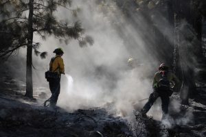
The National Weather Service has issued Fire Weather Watches for Friday and Saturday due to the combination of strong winds, low humidity and dry fuels, particularly across western Nevada.
“In addition to fire weather concerns, winds could disrupt outdoor recreation, create hazardous boating conditions, and impact road and aviation travel,” the forecast discussion states.
The best chance for precipitation will arrive along the cold front Saturday into early Sunday morning. Most showers are expected north of Interstate 80, where there is a 10% to 20% chance of up to one-tenth of an inch of rainfall.
As colder air moves into the region, snow levels are expected to drop to between 7,000 and 8,000 feet from the Tahoe Basin north to the Oregon border, creating the possibility of light snow showers.
Temperatures are expected to remain well below average through the remainder of the weekend.


Support Local Journalism
Support Local Journalism
Readers around Lake Tahoe, Truckee, and beyond make the Sierra Sun's work possible. Your financial contribution supports our efforts to deliver quality, locally relevant journalism.
Now more than ever, your support is critical to help us keep our community informed about the evolving coronavirus pandemic and the impact it is having locally. Every contribution, however large or small, will make a difference.
Your donation will help us continue to cover COVID-19 and our other vital local news.