‘No parking’ signs along east Tahoe corridor spark access questions
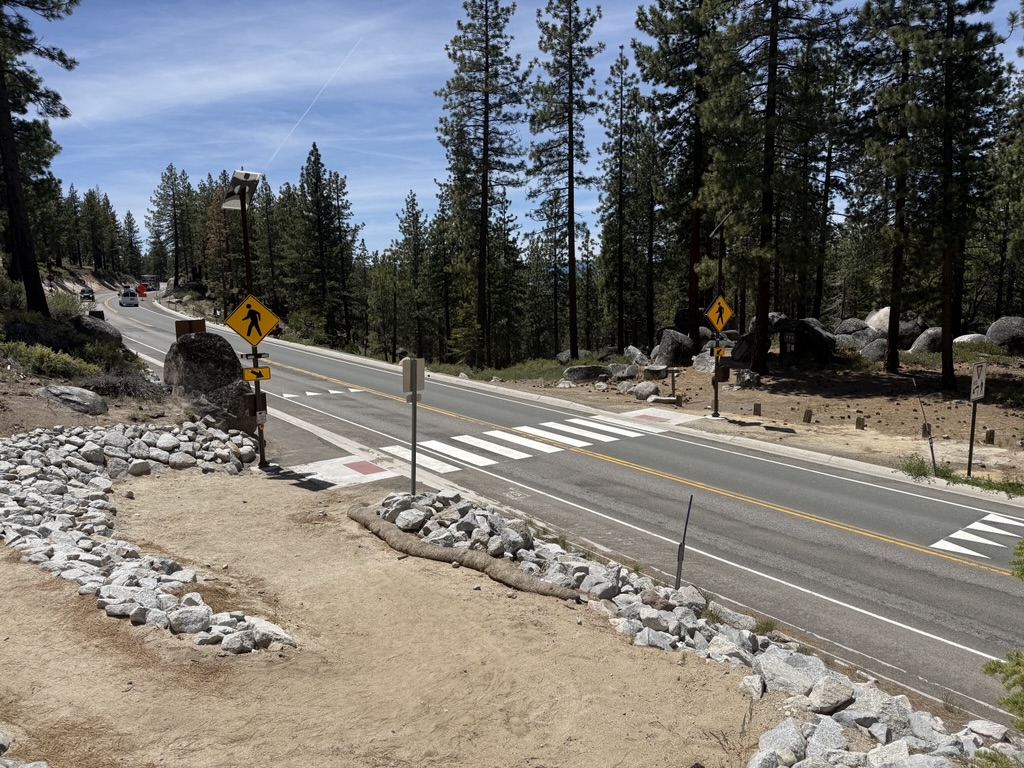
EAST SHORE LAKE TAHOE, Nev. – As Tahoe’s peak season approaches, parking signs stand along Tahoe’s east shore corridor in an attempt to curb dangerous off-shoulder parking along the winding and narrow highway.
The new “No Parking” signs and “20-minute Parking” signs were installed on State Route 28 from south of Sand Harbor to the Carson City line last fall.
Since their placement, parking citations have almost quadrupled compared to a year prior, according to data from the Nevada Highway Patrol. Traffic citations have increased by close to 30%, and crashes have decreased by 24%. The full impact of these changes will become clear as peak season comes into full swing.
State Route 28 receives more than 2.5 million vehicles each year, and in the past, the stretch along Tahoe’s east shore has had as many as 1,000 motorists park on the roadside on peak days, according to the Tahoe Transportation District.
“The goal is to relocate the shoulder parking to designated off-highway parking facilities to promote safety by reducing the potential of pedestrian and other traffic crashes,” Tiara Wasner said with the Tahoe Transportation District.
Some of these off-highway parking facilities just reopened at Secret Harbor and Chimney Beach trailheads in this effort. In addition to more parking, the Chimney Beach project added a lighted crosswalk across the highway, which makes crossing the highway safer for pedestrians.
These newly renovated parking facilities add significant parking capacity but will not fully fill the need for vehicles parking on the side of the highway. Chimney Beach parking increased from 30 spots to 130 spots. Secret Harbor increased from 30 spots to 120 spots. A transit hub, which is currently under construction at Spooner Summit, will add 250 spots.
These spots will only fill 60% of the need but TTD hopes the rest of the need will be filled by public transit once the Spooner transit hub is completed.
These new safety restrictions have left some residents wondering how to get to their favorite spots along the east shore.
The reopened parking locations are over a mile from some of these favorite east shore locations.
When asked how to now access these parts of the shoreline, TTD pointed to their goals of completing off-highway parking facilities and securing funding to extend the East Shore Trail system along that stretch of the east shore to Secret Harbor.
Once the East Shore Trail extension is complete, the trail will provide access by bike or on foot from one of the off-highway parking lots.
These extensions are planned in two phases: first, a one-and-three-quarter-mile extension from Sand Harbor to Thunderbird Cove; and second, a nearly one-mile stretch from Thunderbird Cove to Secret Harbor.
Both are currently in design phases. At this time, TTD does not have an estimate on when these stretches will be completed.
It may not be the ideal answer for those wishing to visit certain east shore locations in the interim, with access appearing to be by a mile-long walk (give or take for the destination) from an off-highway parking lot, drop-off in the 20-minute zone, or by water.
Addressing this stretch has been underway since 2013, when 13 partner agencies came together to improve safety, enhance the visitor experience, expand multimodal transportation, and promote economic vitality through the SR 28 National Scenic Byway Corridor Management Plan (CMP).
The plan also helps protect the lake and its clarity since parking on dirt shoulders can lead to erosion with sediment running into the lake.
One of the first projects along this corridor was the first three miles of the East Shore Trail from Incline Village to Sand Harbor, which opened June 28, 2019.
The adjacent paid parking lot followed, which is currently undergoing an expansion project and is set to add 38 paid parking spaces immediately north of the existing 90 spaces.
The overall corridor plan eventually seeks to incorporate transit stops, with a map currently showing stops at the Spooner transit hub (currently under construction), Secret Harbor, Sand Harbor, Hidden Beach and Incline Village.
The related Nevada Senate Bill 426, which established the Lake Tahoe Basin Scenic Byway Corridor Recreation Safety Zone, took effect Oct. 1. The passed legislation allows agencies to implement traffic control measures on a handful of roads in the Tahoe Basin, including State Route 28. The bill is intended to make major roadways in the basin safer, reduce congestion, and crack down on illegal parking.


Support Local Journalism
Support Local Journalism
Readers around Lake Tahoe, Truckee, and beyond make the Sierra Sun's work possible. Your financial contribution supports our efforts to deliver quality, locally relevant journalism.
Now more than ever, your support is critical to help us keep our community informed about the evolving coronavirus pandemic and the impact it is having locally. Every contribution, however large or small, will make a difference.
Your donation will help us continue to cover COVID-19 and our other vital local news.