The Historic Lincoln Highway: America’s First Transcontinental Auto Route
Provided / ourtesy of https://www.roadsideamerica.com/tip/49344
In the early 1910s, when automobiles were still a novelty to most Americans, cross country travel was an adventure and reserved for only the very hardiest of pioneers. A visionary, Carl Fisher, believed he had an idea whose time had come – to develop America’s first transcontinental highway.
While the highway was named for President Abraham Lincoln, the highway stretched from New York’s Time Square to San Francisco’s Lincoln Park and covered about 3,400 miles, forever changing American lives and the travel industry.
The Very Beginnings of the Lincoln Highway
In the decade of the 1910s, when few Americans actually owned cars, the existing roadway system in America was a hodgepodge of local trails, many of them impassable during harsh and wet weather. Fisher recognized the need for proper roads to accommodate the burgeoning automobile interest and ownership.
Already familiar with the automotive industry, Fisher, along with Henry Joy, President of The Packard Motor Car Company and Frank Seiberling, Founder of The Goodyear Tire & Rubber Company, created the Lincoln Highway Association (LHA) to promote and develop this audacious and ambitious coast-to-coast road plan. Fisher must have envisioned and recognized that as the transcontinental railroad united the country by rail, so too would a roadway further unite the country by automobile travel.
The original 1913 route linked thirteen states, but one of the most challenging sections was through California.
The California Route
The planned route through the Sierra Nevada mountains proved to be one of the most challenging on the entire coast to coast route, navigating the treacherous Sierra Nevada mountains before descending on the more level slopes heading towards the San Francisco Bay area. The California section passed through smaller towns – like Truckee and Auburn – which became vital waypoints for these intrepid transcontinental travelers. Enterprising businesses sprang up along the highway route which offered essential services like fuel, food, and lodging for the early wayfarers. Many of these early pioneer waystations were referred to as “canteens” and with the growth of the automobile related businesses, a distinct American “road culture” was born.
There is a particular stretch of road over the original route that still remains much as it was in those inaugural late 1910 -1920 automobile travel years. There is a road near Truckee called Dog Valley Road that still appears much as it originally did, and travelers today can get a real feel for what it may have been like for those intrepid adventurous souls.
Evolution and Transformation (1913-1928)
During the fifteen years from its infancy, the Lincoln Highway underwent route improvements that combined many existing local roads which varied in quality – some well-maintained gravel roads, even primitive pavement, but some roads were little more than dirt tracks that became impassable during inclement weather.
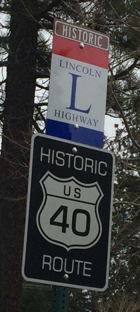
The LHA worked very hard to improve road conditions, coordinating with local governments to do so, installed consistent signage for drivers, and both promoted and established reliable canteen services for travelers. The iconic red, white and blue Lincoln Highway markers are the last vestiges of times gone by and are a reminder to today’s drivers that these signposts along the road guided motorists across the country. These distinctive signs were the first standardized highway signage system markers.
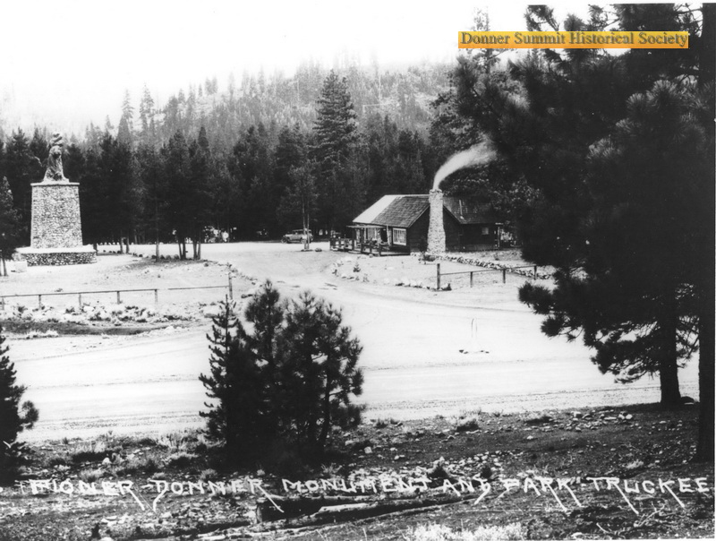
Donner Memorial State Park Visitor Center once had a canteen service center on its premises, run by a T.C. Wohlbruck from San Francisco. A noted photographer there, he built an enterprising business catering to motorists exploring the Lincoln Highway near Donner Summit. The highway followed much of the original Dutch Flat Donner Lake Wagon Road and in fact, today’s Donner Pass Road follows much the same route.
Courtesy of Donner Summit Historical Society, image # DSHS3306 showing T.C. Wohlbruck’s “Canteen” Service station, directly west of the Pioneer Donner Monument. This road in the foreground is the old Lincoln Highway.
Replica of an original Lincoln Highway marker along current Donner Pass Road near Donner Summit
The Legacy Continues
Even though the Lincoln Highway’s glory years ran from 1913-1928, the road demonstrated that transcontinental travel was possible and in fact, paved the way for Historic U.S. Route 40 which began on November 11, 1926, when the U.S. Numbered Highway System was formally approved. Historic U.S. Route 40 would last until approximately 1964 when Interstate 80 displaced the old route through the local communities giving way to the Federal Interstate Freeway System we still use today.
Join us for the program
As part of the Museum of Truckee History’s continuing Summer Speaker Series, Lincoln Highway Association California Chapter Member Andrew Wayne Saunders will present a program at the Truckee Tahoe airport on Tuesday, September 16 at 6 p.m. to talk about the origins of the Lincoln Highway. Part of his program will include a short excerpt from a recent auto trip Andrew took over this same stretch of highway, still looking much the same as it first did in the 1920s.
Andrew will also offer comments about a more recent undertaking, working on a project on the Sacramento – Sierra Historic Lincoln Highway Travel Corridor. An active Speaker in the Northern California Region, Andrew is trying to form a Regional Destination for Historic Travel hoping to be recognized by the state of California Travel and Tourism board on their website http://www.visitcalifornia.com, encouraging visitors to exit the Interstate 80 Freeway at strategic locations and visit significant points of interest located on the LHA map at https://www.lincolnhighwayassoc.org/map/ .
Please join us for a fascinating look into the history of the iconic Lincoln Highway.
About the Author:
Heidi Sproat lives part time in Truckee. She is the Truckee-Donner Historical Society’s webmaster for truckeehistory.org, and manages the Image Collection currently available for viewing on the Society’s website at images.truckeehistory.org .


Support Local Journalism
Support Local Journalism
Readers around Lake Tahoe, Truckee, and beyond make the Sierra Sun's work possible. Your financial contribution supports our efforts to deliver quality, locally relevant journalism.
Now more than ever, your support is critical to help us keep our community informed about the evolving coronavirus pandemic and the impact it is having locally. Every contribution, however large or small, will make a difference.
Your donation will help us continue to cover COVID-19 and our other vital local news.