New historical landmark recognized in Tahoe National Forest
TRUCKEE, Calif. — The Nevada County Board of Supervisors has officially designated the remnants of an 1870s U.S. Coast and Geodetic Survey station on Mount Lola as a Nevada County historical landmark, recognizing its scientific and historical significance.
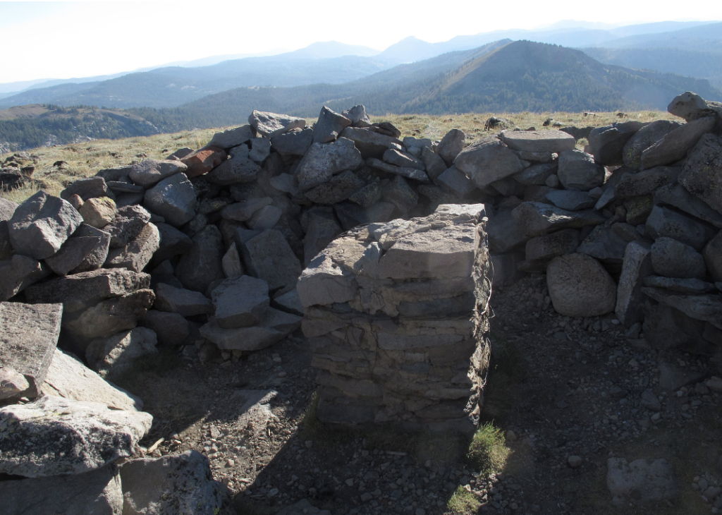
Located near Independence Lake in the Tahoe National Forest, the site dates back to a groundbreaking 1878 geodetic survey across the western United States.
The survey, led by Professor George Davidson, used a sophisticated triangulation system to connect major mountain peaks, including Mounts Shasta, Lola and Helena. Davidson and his team scaled numerous summits to conduct long-distance observations critical to advancing geodesy — the science of measuring and understanding the Earth’s geometric shape and surface.
“The whole purpose was to map the entire Pacific to create the maps that we use today,” said Chuck Scimeca, a member of the Nevada County Historical Landmarks Commission.
On Aug. 1, 1878, Davidson established a station on Mount Lola, from which he successfully signaled Mount Shasta — 169 miles away — using reflected sunlight. This record-setting achievement became a milestone in geodetic science and significantly improved the accuracy of mapping and surveying across the western U.S.
“The success of the survey was a point of national pride and set new global records,” Scimeca said. “It advanced the accuracy of continental mapping.”
Surviving elements of Davidson’s station include the foundations of the heliotrope and theodolite platforms, along with remnants of the shelter used by the survey team. A heliotrope is a surveying device that reflects sunlight to distant observers, while a theodolite is a precision instrument used to measure angles for triangulation.
“Mount Lola is also significant for recreationalists,” said Scimeca.
Reaching the site is no small feat. Hikers must complete a strenuous six-mile route along Cold Stream Creek, climbing approximately 2,500 feet through rugged terrain.
The Nevada County Historical Landmarks Commission is actively working to raise public awareness of the Mount Lola Survey Station through interpretive signage, educational materials and digital outreach.
“Some of the things that you have brought forward are so important to the history of our county, and its preservation is important,” said Vice Chair Lisa Swarthout.
The landmark designation was presented by the Nevada County Historical Landmarks Commission and officially approved by the Board of Supervisors on Tuesday, Aug. 12.


Support Local Journalism
Support Local Journalism
Readers around Lake Tahoe, Truckee, and beyond make the Sierra Sun's work possible. Your financial contribution supports our efforts to deliver quality, locally relevant journalism.
Now more than ever, your support is critical to help us keep our community informed about the evolving coronavirus pandemic and the impact it is having locally. Every contribution, however large or small, will make a difference.
Your donation will help us continue to cover COVID-19 and our other vital local news.